


Understanding METAR Structure: Your Foundation for Safe Flying
Every pilot knows that safe flying depends on accurate weather information. This is why understanding how to read METAR reports is so crucial. These reports aren’t just random strings of characters. They follow a specific structure, a standardized language that allows pilots worldwide to access critical weather data. This standardization is the bedrock of safe and efficient flight operations.
Why Structure Matters in METAR Reports
Think of a METAR report like a precisely engineered aircraft component. Each part has its place and purpose, contributing to the overall functionality. Similarly, each element within a METAR report occupies a specific position, conveying essential information concisely and consistently. This structure allows pilots to quickly locate and interpret the data they need, even under pressure. For example, the wind information always appears in a designated spot, making it easy to assess wind speed and direction at a glance.
This wasn’t always the case. Before the standardization of METAR reports, weather information could vary in format and reliability, posing significant challenges to pilots, especially during international flights. Understanding METAR reports is foundational for pilots and aviation professionals worldwide.
You might also be interested in: How to master navigational aids
The International Adoption of METAR
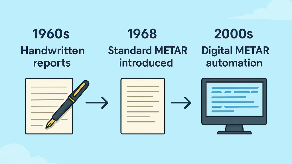
Industry standards mandate that all METARs use a specific coded format to ensure global interoperability. The international adoption of the format on January 1, 1968, marked a significant milestone for safer and more efficient international air traffic. By 2022, this had grown to include over 40,000 commercial flights daily. This structured format minimizes the risk of misinterpretation and ensures consistent and reliable information for pilots, regardless of location.
The Historical Development of METAR Format
The current METAR format is a product of years of refinement and international collaboration. This evolution reflects the aviation industry’s ongoing commitment to enhancing safety and efficiency. The standardized format enables seamless communication between pilots, air traffic control, and meteorological services across the globe.
This interoperability is essential for coordinating flights, managing air traffic, and ensuring safe operations in diverse weather conditions. The structured nature of METAR reports also allows for easy integration with automated weather systems and flight planning software.
How Standardization Impacts Your Daily Flight Operations
The standardized structure of METAR reports directly benefits your daily flight operations in several ways.
- Quick and Accurate Interpretation: Enables informed decisions about flight planning, route selection, and alternate airport choices.
- Reduced Delays and Diversions: Minimizes disruptions caused by unexpected weather changes.
- Enhanced Situational Awareness: Improves the ability to anticipate and respond to changing weather conditions during flight.
The standardized METAR structure contributes significantly to a safer and more predictable flying environment.
Why Understanding METAR Reports Still Matters in the Age of EFBs
While modern Electronic Flight Bags (EFBs) like ForeFlight and Garmin Pilot automatically translate METAR reports into plain English, it’s still essential for pilots to understand the original coded format. Technology can make interpretation easier, but it’s not infallible.
A firm grasp of METAR structure ensures that pilots can verify information, recognize any discrepancies, and make fast, accurate decisions, especially in high-pressure situations where clarity and precision are critical. Mastering METARs isn’t just about tradition; it’s about building the confidence and situational awareness that every safe pilot relies on.
Decoding the 11 Essential Data Groups Like a Pro
METAR reports can contain up to 11 groups of data, offering a complete overview of current weather conditions at a specific airport. This information is necessary for safe flight planning and execution.
For example, a typical observation might include wind data like 210/10G20KT, visibility of 6SM, broken clouds at 3500 feet, a temperature of 15°C, a dew point of 10°C, and a pressure of 29.92, along with any necessary remarks. Each group, from wind speed and direction (measured in knots) to visibility, cloud cover, temperature, dew point, and pressure readings, plays a vital role.
Identifying the Key Data Groups
Understanding each data group is the first step in decoding a METAR report. These groups appear in a specific order, allowing pilots to quickly find the information they need.
Let’s break down each of the 11 potential data groups:
Station Identifier: The four-letter code that identifies the airport (e.g., KLAX for Los Angeles International Airport).
Date and Time: The date and time of the observation, expressed in Coordinated Universal Time (UTC).
Modifier: Indicates whether the observation is automated (AUTO) or corrected (COR).
Wind: Wind direction, speed, and gusts (e.g., 27015G25KT indicates wind from 270° at 15 knots, gusting to 25 knots).
Visibility: Prevailing visibility, measured in statute miles or meters.
Weather Phenomena: Current weather conditions such as rain (RA), snow (SN), or fog (FG).
Cloud Cover: The amount and height of cloud layers (e.g., OVC030 represents overcast clouds at 3,000 feet).
Temperature and Dew Point: Temperature and dew point, measured in degrees Celsius.
Altimeter Setting: Atmospheric pressure used to calibrate altimeters (inches of barometric pressure in the United States, hPa elsewhere).
Recent Weather: Significant weather events that occurred recently but are no longer present.
Remarks: Additional information not included in the other groups.
Try it for yourself here! Enter an airport identifier (KLAX, for example) to see a live METAR report.
To further clarify these data groups, let’s examine them in a table format:
| Data Group | Code Format | Example | Description |
|---|---|---|---|
| Station Identifier | 4-letter code | KJFK | JFK International Airport |
| Date and Time | YYGGggZ | 221250Z | 22nd of the month, 12:50 UTC |
| Modifier | AUTO/COR | AUTO | Automated observation |
| Wind | dddff(Ggg)KT | 32010KT | Wind from 320° at 10 knots |
| Visibility | nnSM/nnnnM | 10SM | 10 statute miles |
| Weather Phenomena | Various codes | – | No significant weather |
| Cloud Cover | SKC/FEW/SCT/BKN/OVCnnn | CLR | Clear skies |
| Temperature and Dew Point | tt/dd | 25/15 | Temperature 25°C, Dew Point 15°C |
| Altimeter Setting | Qpppp | Q2992 | Altimeter setting 29.92 |
| Recent Weather | REwx | – | No recent weather |
| Remarks | RMK… | – | No remarks |
This table summarizes the key components of a METAR report, offering a quick reference for interpreting these crucial weather messages. Understanding these codes is fundamental for accurate weather interpretation.
Read also: How to master pilot weather briefing.
Practical Examples of METAR Decoding
Let’s illustrate how these groups work together with a simplified example:
KJFK 221250Z AUTO 32010KT 10SM CLR 25/15 Q2992
This METAR tells us the following about JFK International Airport:
Observation taken on the 22nd of the month at 12:50 UTC.
Wind from 320° at 10 knots.
Visibility 10 statute miles.
Clear skies.
Temperature 25°C, dew point 15°C.
Altimeter setting 29.92
Mastering the Art of METAR Interpretation
While each data group provides valuable information, the combined picture is what truly matters. By understanding how to read and interpret these groups, pilots can make informed decisions about flight safety. This means assessing current conditions, anticipating potential changes, and planning accordingly.
For example, low visibility combined with low cloud cover might require an instrument approach or even diverting to another airport.
Why This Matters for Pilots
The ability to quickly and accurately decode METAR reports is a fundamental skill for any pilot. It enables better preflight planning, safer in-flight decisions, and more efficient operations. Having a solid understanding of METAR reports ensures pilots are equipped to make informed decisions based on the most current and accurate weather information.
Modern Weather Systems: How Your METAR Data Gets Generated
Understanding the technology behind METAR reports makes you a smarter consumer of weather information. For pilots, this translates to safer and more efficient flight operations. This section explores how today’s weather systems generate the data that forms the core of these vital reports.
From Manual Observations to Automated Systems
Historically, weather observations at airports relied on trained observers manually checking instruments and visually assessing conditions. This method, while effective for its time, had limitations in terms of frequency and consistency. The growing need for more reliable and frequent data spurred the development of automated systems.
These Automated Surface Observing Systems (ASOS) and Automated Weather Observing Systems (AWOS) represent a significant leap forward in aviation weather reporting. The very format of the METAR report has adapted to accommodate this shift towards digital automation and integration with other crucial aviation systems.
From 1968 to the present day, aviation weather systems have undergone this transition. Approximately 90% of major airports worldwide now utilize ASOS/AWOS to generate METAR reports. This automation has dramatically improved the frequency and reliability of these critical weather reports.
You can explore more about METAR reports here.
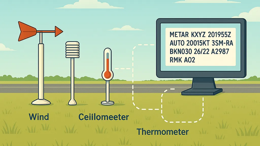
How ASOS/AWOS Works
ASOS/AWOS stations employ an array of sensors to capture a comprehensive picture of current weather conditions. These complex systems measure various parameters using specific instruments.
- Wind Speed and Direction: Measured by anemometers and wind vanes.
- Visibility: Transmissometers determine visibility by measuring how much light passes through a given distance.
- Precipitation: Specialized sensors detect and quantify precipitation, differentiating between rain, snow, and other types.
- Cloud Height and Coverage: Ceilometers employ lasers to measure cloud base heights.
- Temperature and Dew Point: Electronic temperature sensors provide precise readings for temperature and dew point.
- Air Pressure: Barometers measure air pressure, a critical component for calculating the altimeter setting used by aircraft.
The data from these sensors is then processed and formatted into the standardized METAR report, ensuring consistency and easy dissemination to pilots and other aviation professionals. This automation guarantees regular updates, typically hourly, with increased reporting frequency when conditions change significantly.
Benefits of Automated Systems
The widespread adoption of ASOS/AWOS has significantly enhanced weather reporting for aviation. The key advantages include:
- Increased Frequency of Observations: Pilots receive more up-to-date information, crucial for safe flight planning and execution.
- Improved Data Consistency: Standardized measurements minimize the risk of human error, improving the reliability of the reports.
- Enhanced Reliability: ASOS/AWOS systems are designed for continuous, robust operation in a wide range of weather conditions.
- Cost-Effectiveness: Automation reduces the need for continuous human monitoring, making it a more efficient use of resources.
These benefits have made ASOS/AWOS indispensable for modern aviation weather reporting.
Limitations of Automated Systems
While ASOS/AWOS represents a significant improvement, these systems are not without their limitations. They may not always be able to accurately detect or report certain weather phenomena:
- Variable or Rapidly Changing Winds: Sudden shifts in wind speed or direction might not be immediately reflected in the METAR.
- Localized Weather Conditions: Conditions can vary considerably within an airport’s area, and the ASOS/AWOS may not capture these microclimates.
- Certain Types of Precipitation: Differentiating between specific precipitation types, like freezing rain and ice pellets, can sometimes pose a challenge for automated systems.
Therefore, pilots should always consider supplementary weather information sources. Pilot reports (PIREPs) and radar imagery offer valuable context and can help provide a more complete picture of prevailing weather conditions. Recognizing these limitations allows pilots to make informed decisions about when to seek additional information and interpret potentially unusual readings. These automated systems are valuable tools, but they should be used in conjunction with sound judgment and other available resources.
Avoiding Costly METAR Reading Mistakes
Even with the standardized format of METAR reports, misinterpretations can happen, sometimes with serious consequences. This is especially true for newer pilots or those less familiar with international aviation codes. Up next are common pitfalls and strategies for accurate METAR interpretation to improve flight safety. For a deeper dive into safe decision-making in aviation, check out our guide on Aeronautical Decision Making.
Common Errors in METAR Interpretation
While METAR reports have a defined structure, certain elements are easily misinterpreted. One common mistake is confusing visibility measurements, mixing up statute miles and meters. Misreading wind information, particularly when gusts are present, can also lead to incorrect crosswind calculations.
Another area requiring careful attention is the interpretation of cloud layers, especially when multiple layers are reported. Accurate interpretation is essential for safe flight operations. Furthermore, understanding the relationship between temperature and dew point, and how it influences cloud formation, is crucial. This is especially important for predicting visibility changes, particularly near the ground, and the likelihood of fog.
Finally, despite the structured coding of METAR reports, errors can still occur. These errors are more frequent among newer pilots or those less familiar with international aviation codes. Between 2010 and 2020, misinterpreting METAR data contributed to several incidents globally. One U.S. study found that approximately 2% of weather-related incidents involved pilots misreading METAR elements. This underscores the importance of accurately interpreting these reports. (You can find more detailed statistics from the Iowa Environmental Mesonet here.)
Strategies for Accurate METAR Reading
Pilots can minimize errors by using a systematic approach when reviewing METAR reports.
Double-Checking Key Elements: Always double-check critical information such as wind direction, speed, visibility, and cloud ceilings.
Using a METAR Decoder: Online METAR decoders can help verify your understanding, particularly for unfamiliar codes or complex reports.
Cross-Referencing with Other Weather Sources: Compare the METAR with TAFs, radar imagery, and pilot reports (PIREPs) to get a complete picture of the current weather.
Practicing Regularly: Regularly decoding METARs from different airports and varying weather conditions improves both speed and accuracy.
How Fatigue and Stress Affect Interpretation
Fatigue and stress can significantly impair cognitive function, making misreading critical information more likely. Pilots should be mindful of these factors and take steps to mitigate their impact.
Getting Adequate Rest: Prioritize sufficient rest before preflight planning and flight duties.
Minimizing Distractions: Create a focused environment to minimize distractions and reduce the risk of errors.
Taking Breaks: Short breaks during long flights or when dealing with complex weather can improve concentration and reduce stress levels.
What Professional Pilots Do
Professional pilots use established procedures to ensure consistent METAR analysis. These practices are vital for maintaining accuracy, especially in high-pressure situations.
Standard Operating Procedures: Airlines and other aviation organizations have detailed procedures for interpreting and using METAR data.
Crew Resource Management (CRM): Pilots utilize CRM principles to cross-check each other’s understanding of weather conditions.
Recurrent Training: Ongoing training helps pilots stay proficient in interpreting METAR reports and other crucial weather information.
By adopting these strategies, pilots can significantly enhance the accuracy of their METAR interpretations, contributing to safer flight operations.
Real-World METAR Decoding Practice Sessions
Nothing builds confidence in reading METAR reports like hands-on practice. This section provides practical exercises using real-world METAR examples from various airports and weather scenarios. We’ll break down complex reports step by step, demonstrating how experienced pilots tackle challenging situations involving multiple cloud layers, variable winds, and special weather phenomena. Each practice session reinforces the systematic approach used in real flight operations, helping you develop the speed and accuracy required for confident decision-making.
Building Your METAR Decoding Skills
These practice sessions aim to build essential skills beyond simply deciphering codes. You’ll learn to recognize patterns in weather data, understand regional variations in reporting, and develop quick-scanning techniques that make METAR analysis second nature. This is crucial for adapting to the diverse conditions you’ll face throughout your flying career.
Practice Example 1: Decoding a Complex METAR
Let’s start with a more complex METAR report:
CYVR 221850Z 03008KT 15SM FEW040 SCT080 BKN250 15/10 Q3002
This METAR, from Vancouver International Airport (CYVR), might appear daunting at first glance. However, by applying a systematic approach, we can unlock valuable insights. The following table, “METAR Decoding Practice Examples,” provides a step-by-step breakdown with explanations and potential flight impacts.
To understand this METAR report, we’ll break it down piece by piece, exploring what each element signifies and how it could influence a flight.
| Raw METAR | Decoded Element | Meaning | Flight Impact |
|---|---|---|---|
| CYVR | Station Identifier | Vancouver International Airport | Identifies the reporting location |
| 221850Z | Date and Time | 22nd of the month, 18:50 UTC | Shows the report’s timeliness |
| 03008KT | Wind | Wind from 030° at 8 knots | Affects runway selection and takeoff/landing |
| 15SM | Visibility | 15 statute miles | Excellent for Visual Flight Rules (VFR) |
| FEW040 | Cloud Cover | Few clouds at 4,000 feet | Minimal VFR impact |
| SCT080 | Cloud Cover | Scattered clouds at 8,000 feet | Ample VFR flight opportunities |
| BKN250 | Cloud Cover | Broken clouds at 25,000 feet | Generally not a VFR concern |
| 15/10 | Temperature/Dew Point | Temperature 15°C, Dew Point 10°C | Moderate spread, relatively low humidity |
| Q3002 | Altimeter Setting | 30.02 | Crucial for accurate altitude readings |
Read also: How to master turbulence
Practice Example 2: Recognizing Special Weather Phenomena
Now consider this METAR:
KJFK 230050Z 30015G25KT 1/2SM +RA BR BKN005 OVC010 05/04 Q2995 RMK RAB05
This METAR from JFK International Airport (KJFK) presents more challenging conditions. The following table breaks down the key elements, including their meanings and potential flight impacts.
This example dives into a more complex scenario with challenging weather conditions, emphasizing the importance of understanding all elements of a METAR.
| Raw METAR | Decoded Element | Meaning | Flight Impact |
|---|---|---|---|
| KJFK | Station Identifier | JFK International Airport | Identifies the reporting location |
| 230050Z | Date and Time | 23rd of the month, 00:50 UTC | Shows the observation time |
| 30015G25KT | Wind | Wind from 300° at 15 knots, gusting to 25 knots | Strong, gusty winds challenging for takeoff/landing |
| 1/2SM | Visibility | Half a statute mile | Very low visibility, likely Instrument Flight Rules (IFR) required |
| +RA BR | Weather Phenomena | Heavy rain and mist | Reduced visibility, adds to landing difficulty |
| BKN005 OVC010 | Cloud Cover | Broken clouds at 500 feet, overcast at 1,000 feet | Very low ceiling, requires IFR procedures |
| 05/04 | Temperature/Dew Point | Temperature 5°C, Dew Point 4°C | Small spread, indicating high humidity and potential fog |
| Q2995 | Altimeter Setting | 29.95 | Important for accurate altitude |
| RMK RAB05 | Remarks | Rain began at 00:05 UTC | Additional weather context |
Mastering METARs for Real-World Flying
Engaging in regular decoding practice with varied METAR scenarios will help you develop the essential skills to confidently assess weather conditions. This mastery is vital for making informed decisions that prioritize flight safety and operational efficiency.
Making Smart Flight Decisions with METAR Intelligence
Reading METAR reports isn’t just about decoding a string of characters; it’s about transforming that raw data into actionable intelligence for safer and more efficient flights. This means going beyond simply understanding the individual elements and learning how to integrate METAR data with other crucial information sources to form a complete weather picture.
Integrating METAR Data with Other Weather Resources
A single METAR report provides a snapshot of current conditions at a specific airport at a particular moment. However, weather is dynamic, and conditions can change rapidly. Therefore, METAR reports should be used in conjunction with other weather resources for a more comprehensive understanding.
Terminal Area Forecasts (TAFs): TAFs provide a forecast of expected weather conditions at an airport, typically covering a 24-hour period. Integrating TAFs with METARs allows pilots to anticipate changes and make proactive decisions.
Radar Imagery: Radar images show the location and intensity of precipitation, offering valuable insight into the movement and development of weather systems. This visual representation complements the textual data in a METAR, offering a broader perspective.
Pilot Reports (PIREPs): PIREPs are real-time reports from pilots in the air, describing actual encountered conditions. They provide valuable on-the-ground insights that may not be reflected in automated observations. Integrating PIREPs with METARs adds a human element to the data, offering firsthand perspectives on weather phenomena.
Combining these resources helps pilots build a much more complete and dynamic understanding of the weather situation. This integrated approach allows for a more informed and flexible flight plan.
METARs and Go/No-Go Decisions
METAR information plays a vital role in the critical go/no-go decision-making process. Current conditions, as reported in the METAR, can significantly impact whether a flight is safe to commence. For example, low visibility, strong crosswinds, or thunderstorms reported in a METAR could all be reasons to delay or cancel a flight. Conversely, a favorable METAR can provide the confidence needed to proceed with the flight as planned. It’s important to remember that safety is paramount, and a go/no-go decision should always prioritize caution.
Alternate Airport Selection with METARs
When planning a flight, pilots often identify alternate airports in case the destination becomes unusable due to weather. METAR reports are essential for selecting suitable alternates. By checking the METARs for potential alternate airports, pilots can ensure they have viable options available if conditions deteriorate at their primary destination. This preparedness is crucial for minimizing disruptions and ensuring a safe and efficient flight.
Check out our guide on How to master a flight computer for tips on calculating fuel requirements for alternate destinations.
Fuel Planning Considerations and METARs
Weather can significantly impact fuel consumption. Strong headwinds can increase fuel burn, while tailwinds can reduce it. METAR information, specifically wind data, can be used to refine fuel calculations and ensure adequate reserves for the planned flight. Additionally, if an alternate airport becomes necessary due to weather at the destination, having accurate fuel calculations is essential. This careful planning helps prevent fuel exhaustion, a critical safety concern.
Scenario-Based Examples from Working Pilots
Let’s explore how working pilots use METARs in real-world situations:
Scenario 1: A pilot is preparing for a cross-country flight. The destination METAR reports low visibility and ceilings below minimums. By checking TAFs and radar imagery, the pilot determines that conditions are expected to improve within a few hours. The pilot decides to delay the departure to avoid encountering potentially hazardous conditions.
Scenario 2: A pilot is approaching their destination airport. The current METAR reports gusty crosswinds exceeding the aircraft’s limitations. The pilot checks the METAR for a nearby alternate airport, which reports calmer winds. The pilot makes the informed decision to divert to the alternate, prioritizing safety and a smoother landing.
Scenario 3: A pilot is planning a flight into an area known for rapidly changing weather. The destination METAR reports acceptable conditions, but the pilot also checks PIREPs. A recent PIREP indicates deteriorating conditions, including unexpected turbulence. Armed with this additional insight, the pilot decides to postpone the flight, prioritizing caution.
These examples highlight the importance of using METAR data strategically, integrating it with other weather information to make informed decisions.
Developing Sound Judgment in Weather Analysis
Consistently applying a systematic approach to weather analysis, using METARs alongside TAFs, radar, and PIREPs, helps pilots develop the crucial judgment skills needed to translate raw data into actionable flight plans. This confident decision-making is essential for enhancing safety throughout an aviation career. It allows pilots to anticipate, adapt, and make the best choices to ensure safe and efficient flight operations.
Recent Posts
FAA MOSAIC Final Rule: What Pilots, Manufacturers, and the Aviation Community Need to Know
Learn how the FAA’s MOSAIC final rule revolutionizes Light-Sport Aircraft certification, expands Sport Pilot privileges, and reshapes general aviation. See what’s changing, when it takes effect,...
Student Pilot Insurance: Essential Coverage for Aspiring Flyers
Discover how student pilot insurance can protect your flying dreams. Get expert tips and coverage options to ensure your safety and peace of mind.