

Wind direction plays a crucial role in aviation, influencing flight safety, efficiency, and overall performance. Pilots must have an accurate understanding of wind conditions at various altitudes and locations throughout their journey. This article delves into the methods and technologies used by pilots to determine wind direction, both before takeoff and during flight, and the impact of wind on flight planning.
How Do You Know Where the Wind is Coming From When Flying?
When flying, pilots use a combination of pre-flight information, in-flight techniques, and advanced technologies to determine where the wind is coming from. The primary method is through pilotage but also includes meteorological reports and forecasts, windsocks and wind indicators at airports, pre-flight briefings, and communication with Air Traffic Control (ATC).
Methods for Determining Wind Direction Before Takeoff
Meteorological Reports and Forecasts
To prepare for a flight, pilots consult a variety of weather reports and forecasts, including:
- METARs (Aviation Routine Weather Reports): These are concise, hourly reports that provide information about weather conditions at a specific airport. METARs include details such as wind speed, wind direction, and gusts, which enable pilots to anticipate the conditions they will encounter during takeoff and landing.
- TAFs (Terminal Aerodrome Forecasts): These forecasts offer predictions of weather conditions, including wind direction and speed, for a specified period (usually up to 24 hours) at a particular airport. TAFs help pilots make informed decisions regarding their flight route and anticipated fuel consumption.
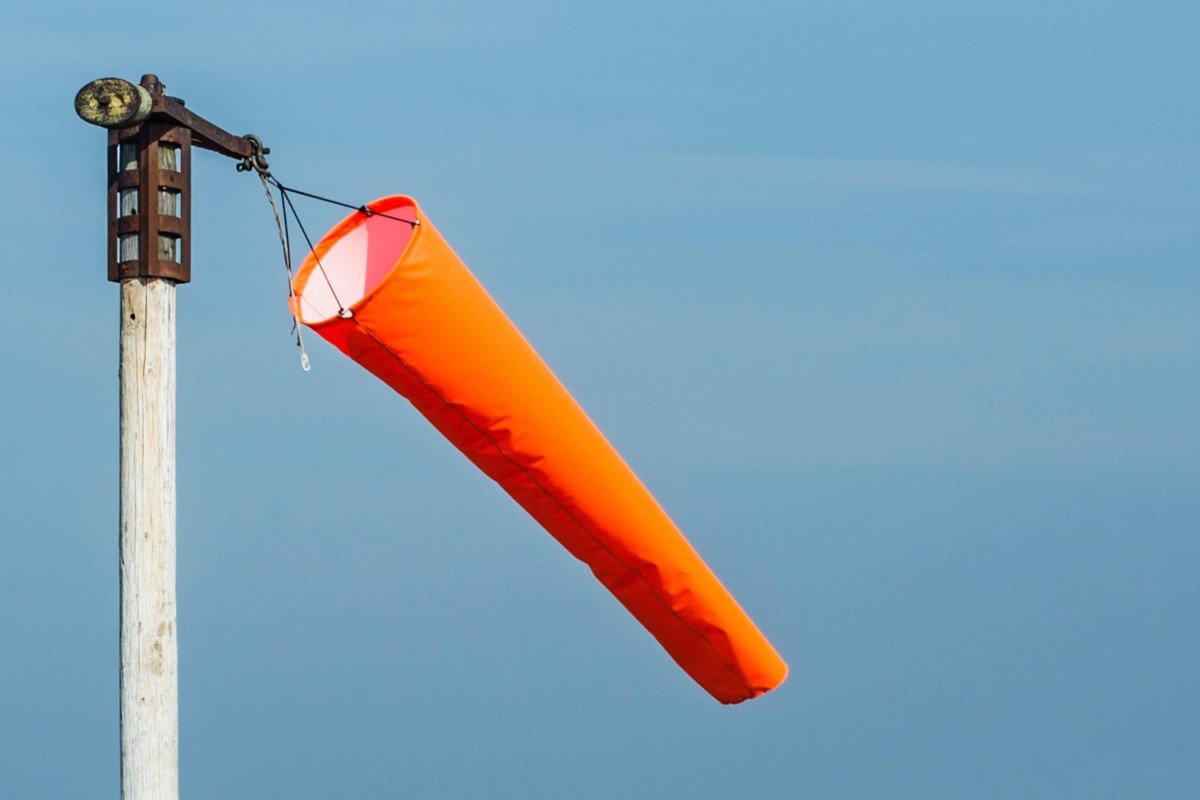
Windsocks and Wind Indicators at Airports
Visible wind indicators, such as windsocks, provide a quick and easy way for pilots to assess wind direction and strength on the ground. These simple, yet effective tools respond to wind currents, displaying the prevailing wind direction and an approximation of its speed.
Briefing With Air Traffic Control
Before takeoff, pilots also receive a briefing from Flight Service, which includes updated weather information, including wind direction and strength. This can be done online, via telephone, or even from the airplane.
In-flight Techniques for Determining Wind Direction
Which Instrument is Used by Pilots to Know the Direction of Wind?
There is no single instrument dedicated solely to measuring wind direction in an aircraft. Instead, pilots use a combination of instruments and data sources to determine the wind direction while flying.
Aircraft instruments
Modern aircraft are equipped with a variety of instruments that provide real-time wind data:
- Air Data Computers (ADCs): These sophisticated devices process information from multiple sensors, such as pitot tubes and static ports, to calculate airspeed, altitude, and wind direction.
- Inertial Navigation Systems (INS): INS uses accelerometers and gyroscopes to estimate an aircraft’s position, velocity, and wind direction, even in the absence of external references.
- Global Positioning System (GPS): In conjunction with other onboard instruments, GPS receivers can calculate wind direction and speed by analyzing the aircraft’s ground speed and track.
Pilotage
Pilots can also use their observational skills to determine wind direction while in flight:
- Observing ground features: By examining the movement of clouds, smoke, or bodies of water, pilots can deduce wind direction and make necessary adjustments to their course.
- Drift correction: Pilots monitor their aircraft’s drift, which is the lateral movement caused by crosswinds. By noting changes in drift, they can adjust their heading to compensate for the wind and maintain the desired track.
Communication With Air Traffic Control
During flight, pilots can communicate with ATC and request updated wind information. This is especially helpful when approaching their destination airport or encountering unexpected weather conditions.
Advanced Technologies for Real-Time Wind Information
Flight Planning Applications
ForeFlight is a popular electronic flight bag (EFB) app for pilots, used on iOS devices like iPads and iPhones. It provides a comprehensive suite of tools for flight planning, weather information, charts, navigation, and more. The app helps pilots access critical information, such as wind speed and direction, to ensure safe and efficient flights. A pilot can get wind information in ForeFlight while in flight, provided that their device has access to the internet or is connected to an external ADS-B receiver.
How Do You Get Winds on ForeFlight?
To get wind information on ForeFlight, follow these steps:
- Ensure your device has an active internet connection to access the latest weather data.
- Open the ForeFlight app on your iOS device.
- On the main screen, you’ll find the Maps tab. Tap on it to access the map view.
- Within the map view, you can access various weather overlays. Look for the “Layer” button (usually on the top-left or bottom-left corner), and tap on it.
- In the Layers menu, you’ll find various weather-related options. To view wind information, tap on “Winds Aloft” or “Surface Winds” based on your requirement. “Winds Aloft” will show you wind data at different altitudes, while “Surface Winds” displays wind information at ground level.
- Once you’ve selected the desired wind layer, the map will display wind barbs or wind arrows, indicating wind direction and speed at various locations.
- You can also view wind information for specific waypoints or airports by tapping on them in the map view. This will open a pop-up window with detailed information, including wind speed and direction.
ForeFlight assists pilots in making informed decisions about their flight path, taking into account the wind conditions at various altitudes and locations.
ADS-B (Automatic Dependent Surveillance-Broadcast)
This satellite-based system allows aircraft to broadcast their position, velocity, and other flight data to other aircraft and ground stations. By analyzing ADS-B data, pilots can obtain real-time wind information, enhancing situational awareness and enabling more efficient route planning.
Satellite-Based Weather Services
Pilots can access up-to-date weather data, including wind conditions, through satellite-based services. These systems provide continuous weather updates, allowing pilots to make informed decisions and adjust their flight plans as needed.
Aircraft-to-Aircraft data sharing
Emerging technologies facilitate data sharing between aircraft, enabling pilots to exchange real-time wind information. This collaborative approach enhances overall situational awareness and helps pilots make informed decisions about their flight paths.
Future developments in wind sensing technology
Researchers are exploring new technologies, such as LIDAR (Light Detection and Ranging), to provide even more accurate and timely wind data. These advancements will further improve pilots’ ability to assess wind conditions and respond accordingly.
Effects of Wind Direction on Flight Planning
Fuel Consumption and Efficiency
Wind direction has a significant impact on fuel consumption. Tailwinds can increase an aircraft’s ground speed, resulting in reduced fuel consumption, while headwinds have the opposite effect. Accurate wind data allows pilots to optimize their routes, taking advantage of favorable wind conditions to save fuel and reduce operating costs.
Flight time and Route Optimization
By understanding wind direction and speed, pilots can select the most efficient routes and altitudes, reducing flight time and minimizing delays. This not only benefits airlines and passengers but also contributes to a reduction in greenhouse gas emissions.
Safety Considerations During Takeoff and Landing
Strong crosswinds can pose challenges during takeoff and landing. Accurate wind data helps pilots determine the appropriate runway to use and whether to employ specific crosswind landing techniques to ensure a safe touchdown.
Conclusion
The ability to accurately determine wind direction is paramount for pilots, as it influences flight safety, efficiency, and overall performance. By utilizing a combination of meteorological reports, ground-based wind indicators, onboard instruments, and advanced technologies, pilots can effectively navigate through varying wind conditions. As advancements in aviation technology continue to emerge, pilots will have even greater access to precise wind data, further enhancing safety and efficiency in the skies.
Recent Posts
FAA MOSAIC Final Rule: What Pilots, Manufacturers, and the Aviation Community Need to Know
Learn how the FAA’s MOSAIC final rule revolutionizes Light-Sport Aircraft certification, expands Sport Pilot privileges, and reshapes general aviation. See what’s changing, when it takes effect,...
Student Pilot Insurance: Essential Coverage for Aspiring Flyers
Discover how student pilot insurance can protect your flying dreams. Get expert tips and coverage options to ensure your safety and peace of mind.