


The Pilot’s Blueprint for Successful Cross Country Flights
Planning a cross-country flight is much more than simply connecting point A to point B on a map. It’s a comprehensive process demanding careful attention to detail. This preparation is key for a safer and more enjoyable experience, transforming a potentially daunting task into a structured and manageable workflow.
Understanding the Essentials
Effective cross-country flight planning involves several crucial steps. By breaking down the process into manageable components, pilots can avoid common oversights that could lead to difficulties during the flight.
- Route Selection: This involves choosing the most efficient and safe path to your destination, taking into account factors like airspace restrictions, terrain features, and the availability of suitable airports along the way.
- Weather Analysis: Careful evaluation of current and forecast weather is paramount for safe flight. This analysis informs go/no-go decisions and helps pilots anticipate potential enroute weather challenges.
- Fuel Planning: Precise calculation of fuel needs, including necessary reserves for unforeseen circumstances, is essential. Running out of fuel is never an option.
- Emergency Preparedness: Planning for unexpected situations is crucial. This includes identifying potential emergency landing locations, understanding emergency communication procedures, and ensuring appropriate survival equipment is onboard.
The Importance of a Structured Approach
A well-structured flight plan acts as a pilot’s blueprint for a successful journey. Just as an architect meticulously plans a building’s structure, a pilot must consider a multitude of variables. These range from airspace restrictions and weather patterns to fuel calculations and potential emergency scenarios. This methodical approach, akin to an architect’s blueprint, ensures a solid foundation for a safe and successful flight. For a more detailed guide on flight planning, take a look at this complete guide to flight planning.
Cross-country flight planning requires careful consideration of route, fuel stops, and weather, among other factors. The Federal Aviation Administration (FAA) provides comprehensive resources for flight planning in the United States, covering both domestic and international flights. These resources include crucial information about airspace restrictions, weather forecasts, and necessary documentation for flight plans.
To help illustrate the key elements of cross-country flight planning, let’s examine a table summarizing the core components and their importance.
Before we dive into the specifics of VFR versus IFR planning, the following table outlines the fundamental aspects of any cross-country flight plan. This table emphasizes the importance of each element in ensuring a safe and successful flight.
| Planning Component | Purpose | Critical Considerations |
|---|---|---|
| Route Selection | Determine safest and most efficient route | Airspace restrictions, terrain, airport availability, NOTAMs |
| Weather Analysis | Evaluate current and forecast conditions | Wind, visibility, precipitation, temperature, potential hazards |
| Fuel Planning | Calculate required fuel and reserves | Aircraft performance, winds aloft, potential diversions |
| Emergency Preparedness | Prepare for unforeseen circumstances | Emergency landing sites, communication procedures, survival equipment |
This table summarizes the essential elements that every pilot must address when planning a cross-country flight. A thorough understanding of these components is crucial for a safe and enjoyable journey.
VFR vs. IFR Planning: Key Differences
Planning procedures differ significantly between Visual Flight Rules (VFR) and Instrument Flight Rules (IFR) flights. VFR flights rely primarily on visual navigation and necessitate clear weather conditions. Conversely, IFR flights adhere to specific instrument procedures, enabling pilots to operate in more challenging weather.
This fundamental difference impacts all aspects of flight planning, from choosing a route to determining fuel reserves. For instance, IFR flights require filing a flight plan with a designated alternate airport in case the intended destination becomes unusable. While this isn’t mandatory for VFR flights, identifying a potential alternate landing site is always considered best practice. For those interested in drone operations, UAV Flight Planning introduces relevant concepts for unmanned aircraft systems.
Planning for Success
By embracing a systematic approach, even the most complex cross-country flights become manageable. Experienced pilots rely on a structured framework, methodically considering every detail to ensure both safety and efficiency. This transforms the challenge of flight planning into a rewarding process of informed preparation. You might also find this complete guide to flight planning a helpful resource.
Mastering Route Selection Like a Professional Pilot
Choosing the right route is fundamental to successful cross-country flight planning. It’s the difference between a smooth, enjoyable flight and one that’s potentially stressful. This isn’t simply about finding the shortest distance; it’s about making informed decisions that prioritize both efficiency and safety.
Navigating Complex Airspace
Experienced pilots approach route selection strategically, thinking beyond the straight line between two points. They carefully examine airspace restrictions, understanding that certain areas may be prohibited or require specific clearances.
For example, flying near a major airport often means navigating around complex Class B airspace. This involves understanding the boundaries and communicating effectively with Air Traffic Control. This proactive approach minimizes the risk of airspace infringements and helps keep the flight on schedule.
Optimizing Altitude and Waypoints
Choosing the right cruising altitude is critical. A higher altitude can mean better fuel efficiency and a smoother ride by avoiding low-level turbulence and terrain. However, wind conditions at different altitudes significantly impact the flight.
Pilots analyze winds aloft forecasts to select an altitude with the most favorable tailwind, minimizing flight time and fuel consumption. They also identify strategic waypoints along the route. These waypoints act as navigational checkpoints, simplifying position tracking and making navigation more manageable, especially over long distances.
Planning for Contingencies
Even with meticulous planning, unexpected things happen. Experienced pilots always include alternate airports in their flight plan. These alternates provide a backup if the destination becomes unavailable due to weather, airport closures, or other issues.
Check out our guide on How to plan for alternate airports.
Seasoned aviators also consider potential diversions along the route, identifying suitable landing spots in case of mechanical problems or other emergencies. This forward-thinking approach ensures they are prepared for various contingencies.
Balancing Direct Routing with Practical Considerations
A direct route might seem most efficient, but it’s not always practical. Factors like fuel availability, communication coverage, and emergency landing options influence route selection.
A slightly longer route might offer better access to fuel stops, more reliable communication frequencies, and safer terrain for emergency landings. For example, flying over remote areas with limited emergency landing options might require a route that follows a highway or railroad, improving the chances of a suitable landing site if there’s an engine failure. This underscores the importance of balancing a direct route with practical considerations that enhance safety.
Weather Analysis Strategies That Keep You Safe

Weather is undeniably the most unpredictable factor in cross-country flight planning. Many pilots find interpreting meteorological data a constant challenge. Going beyond the basic forecast is essential for safe cross-country travel. This section explores proven techniques for gathering, analyzing, and applying weather information effectively.
Identifying Hidden Dangers
Standard weather briefings are a good starting point. However, they may not always reveal potentially dangerous patterns. For instance, a briefing might indicate acceptable conditions along your route. But subtle changes in wind direction or temperature could indicate developing thunderstorms that aren’t immediately obvious.
Through discussions with experienced meteorologists and seasoned pilots, we’ll learn how to spot these less apparent risks. Understanding these subtle clues can make a significant difference in flight safety. This added awareness can greatly influence your routing choices, especially when navigating around weather systems.
Regional Weather Evaluation
Weather patterns change drastically across different geographical areas. Mountainous areas experience rapid shifts in wind and temperature. Coastal regions are prone to fog and sea breezes. Understanding regional weather nuances is a crucial element of cross-country flight planning.
We’ll look at practical ways to assess weather conditions based on the specific region you’re flying over. This localized approach to weather analysis can enhance flight safety and efficiency.
The growing demand for better cross-country flight planning is linked to the rise of air travel. Passenger numbers and flights are expected to continue increasing. In 2025, passenger numbers are anticipated to exceed 5 billion for the first time, with flights totaling 40 million globally. This growth presents both opportunities and challenges for the aviation industry. You can find more detailed statistics from the International Air Transport Association (IATA). This increase highlights the critical need for robust weather analysis strategies to safely manage higher air traffic volumes.
Anticipating Weather Changes and Developing Contingency Plans
Weather can change quickly, especially on longer flights. Navigating these changes successfully involves anticipating potential shifts along your route and formulating backup plans. This could involve selecting alternate airports, modifying your altitude, or even postponing your flight.
We’ll also explore strategies for monitoring weather en route and making real-time adjustments to your flight plan. Staying adaptable is key to managing the ever-changing nature of weather.
Think of a cross-country flight like a road trip. You wouldn’t leave home without checking traffic reports and having alternate routes in mind. A comprehensive weather analysis provides the same “traffic report” for your flight, allowing you to avoid “traffic jams” caused by weather. This proactive approach is essential for confident go/no-go decisions and ensuring a safe and enjoyable cross-country flight.
Fuel Planning Techniques That Prevent Emergencies
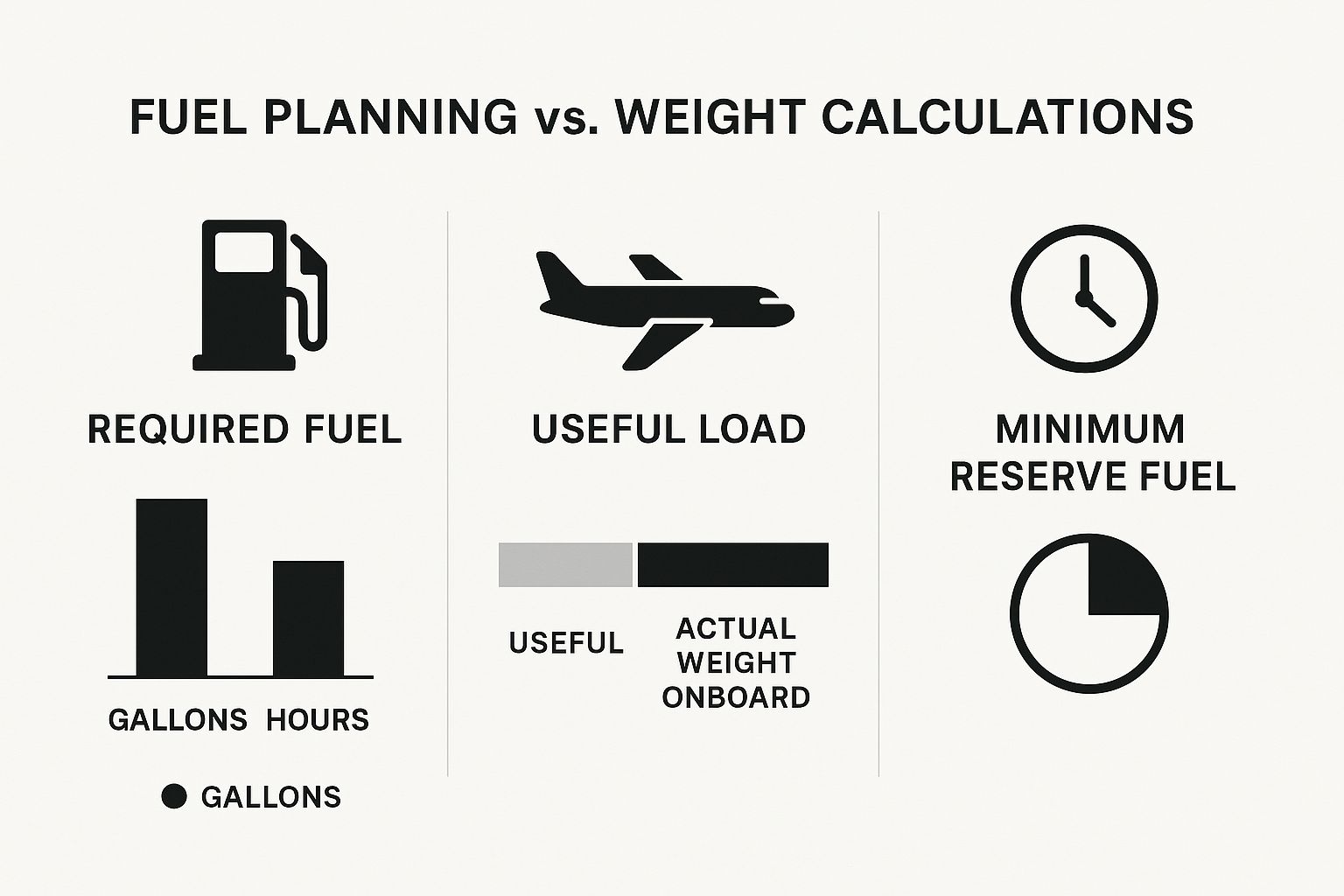
The image below provides a quick overview of key fuel planning data points, comparing them to weight calculations. Notice the emphasis on required fuel, useful load, and minimum reserve fuel – all essential for a safe cross country flight. The visual reminds us to think about fuel not just in gallons, but also in terms of flight hours to ensure we have enough in reserve. It also highlights the critical connection between useful load and actual weight, reminding us to account for passengers, baggage, and cargo. Proper planning for both fuel and weight is non-negotiable for a safe flight.
Fuel miscalculations are a leading cause of avoidable aviation incidents. Accurate fuel planning is absolutely essential for any flight, but especially for cross country trips. It’s a more involved process than simply topping off the tanks. It demands a systematic approach, factoring in everything from aircraft performance and weather conditions to the specifics of your route. For a good primer on the subject, check out this article on fuel planning basics.
Calculating Fuel Requirements
The foundation of effective fuel planning starts with knowing your aircraft’s fuel consumption rate. This figure, typically expressed in gallons per hour, is found in your aircraft’s Pilot Operating Handbook (POH). It’s the baseline for all your fuel calculations.
Forecasted weather conditions also have a major impact. Headwinds will increase your fuel consumption, while tailwinds will reduce it. Using a reliable weather source like ForeFlight or Garmin Pilot is crucial for getting accurate wind forecasts for your route.
Incorporating Reserves and Diversions
Beyond the fuel needed for your planned route, reserve fuel is mandatory. This extra fuel provides a buffer for unexpected situations – think unpredicted headwinds, holding patterns, or diversions. Regulations set a minimum reserve, but many pilots wisely carry more, particularly on longer flights.
Thinking through possible diversions is also key. What if your destination airport suddenly becomes unavailable due to weather? Pre-selecting alternate airports and calculating the fuel required to reach them is a vital part of thorough cross country planning.
To help illustrate the differences in fuel planning between VFR and IFR flights, let’s look at a comparison table.
Fuel Planning Comparison: VFR vs IFR Cross Country Flights
This table compares the different fuel planning requirements and considerations for Visual Flight Rules and Instrument Flight Rules operations.
| Planning Factor | VFR Requirements | IFR Requirements | Best Practices |
|---|---|---|---|
| Reserve Fuel | Typically 30 minutes | Typically 45 minutes to 1 hour | Consider carrying extra fuel beyond the legal minimum, especially in challenging weather or remote areas |
| Alternate Airport(s) | Not always required | Usually required; one for destination and possibly one for enroute if required | Always have viable alternate(s) in mind, even for VFR flights, and know the fuel requirements to reach them |
| Weather Considerations | Significant impact; monitor for changing winds and visibility | Critical impact; requires detailed analysis of forecasts and potential weather deviations | Use up-to-date weather briefings and in-flight updates to adjust planning as needed |
| Fuel Consumption Rate | Same as IFR | Same as VFR | Monitor fuel flow throughout the flight and adjust planning as necessary |
| Flight Planning Tools | Helpful for route and weather analysis | Essential for route, weather, and alternate planning | Utilize a combination of electronic flight bag (EFB) software and traditional paper charts |
This comparison highlights the increased planning demands of IFR flight, particularly concerning fuel reserves and alternate airports. While both VFR and IFR pilots should strive for best practices, IFR regulations often mandate more stringent requirements due to the increased complexity of flying in instrument meteorological conditions.
Monitoring and Adapting In-Flight
Fuel planning isn’t a one-time event; it’s a continuous process throughout your flight. Regular monitoring of your fuel consumption against your plan is essential. This lets you catch any discrepancies early and react accordingly.
For instance, if your fuel burn is higher than expected, you can adjust your plan – perhaps landing at a closer fuel stop or reducing your airspeed to conserve fuel. This proactive approach is vital for avoiding emergencies.
Straightforward Tracking Techniques
Simple strategies can significantly boost your in-flight fuel awareness. Using a flight timer to track actual flight time against your estimated time en route is a great technique. Also, keep a running tally of your fuel burn based on your aircraft’s fuel flow indicator.
These simple checks, combined with regular fuel gauge checks, provide a clear picture of your fuel status throughout your cross country flight. This gives you the confidence to make informed, safety-focused decisions.
Digital Tools That Transform Your Flight Planning
Technology has significantly changed how pilots plan cross-country flights. With so many apps and services out there, it’s essential to determine which ones truly enhance the planning process.

Integrating Essential Digital Resources
Cross-country flight planning involves more than simply plotting a route. Modern digital tools can improve the entire process, from weather analysis and route planning to performance calculations. For example, integrating weather services like ForeFlight or Garmin Pilot gives pilots access to current forecasts, winds aloft data, and radar imagery. This allows for more informed decisions regarding routes and potential weather challenges.
Route planning apps can also help optimize flight paths for fuel efficiency and airspace restrictions. These apps offer three-dimensional route visualization, overlaying terrain, airspace classifications, and even temporary flight restrictions (TFRs). This level of detail facilitates comprehensive route analysis before even stepping into the cockpit. You might also find this helpful: How to master a flight computer. Remember, it’s vital to balance these digital tools with traditional flight planning techniques.
Free Vs. Premium: Finding The Right Balance
Many free digital resources offer significant value for cross-country flight planning. Websites like SkyVector provide free access to aviation charts, route planning tools, and basic weather information. This makes essential planning data readily available for budget-minded pilots.
Premium options, however, unlock more advanced features. ForeFlight and Garmin Pilot, for instance, offer subscription services with premium weather data, advanced flight planning tools, and integrated moving map displays. These features can be worthwhile, especially for those who frequently fly cross-country.
Technology As An Enhancement, Not A Replacement
While digital tools are invaluable for cross-country flight planning, they should complement, not replace, fundamental piloting skills. Pilots must still know how to interpret weather data, make sound aeronautical decisions, and navigate using traditional methods. Depending too heavily on technology can lead to complacency and diminished essential skills.
Experienced pilots strike a balance between technological assistance and sound judgment. They understand that technology is simply a tool, and its effectiveness hinges on the user’s skill.
Building Your Personalized Digital Toolkit
The best digital toolkit varies based on individual needs and flying style. A pilot flying a basic trainer over short distances might find free resources sufficient. A pilot flying a high-performance aircraft over challenging terrain, on the other hand, might need the advanced features of premium subscriptions.
Assess your specific needs and build a digital toolkit that supports your cross-country flying goals. This personalized approach ensures that your digital tools genuinely improve your planning, leading to safer and more efficient flights.
Emergency Preparedness That Makes a Difference
Even with the most detailed cross-country flight planning, unexpected situations can occur. This section highlights the importance of incorporating emergency preparedness into your regular planning process. This proactive approach can significantly improve your ability to handle unforeseen events.
Identifying Emergency Landing Options
A crucial aspect of emergency preparedness is identifying potential emergency landing spots along your route. Imagine your engine fails over a densely forested area with few options. This scenario emphasizes the need to pre-select possible landing sites during your planning stage. Consider open fields, straight sections of highway, or even isolated beaches. Having these locations already in mind reduces stress and facilitates faster decision-making in a real emergency.
Preparing For Communication Challenges
Communication failures can exacerbate the difficulties of an in-flight emergency. Imagine experiencing radio failure over mountainous terrain. Understanding alternative communication methods becomes vital. Familiarize yourself with emergency frequencies and consider carrying a handheld radio or a satellite communication device. This redundancy can be invaluable in a critical situation. This preparation helps ensure you can contact help even if primary systems fail. Learn more in our article about How to master aeronautical decision-making.
Developing Mental Frameworks for Decision-Making
In-flight emergencies demand swift, decisive action. Developing the right mental frameworks beforehand can be the difference between a safe outcome and a catastrophic one. Mental rehearsal of emergency procedures builds automatic responses. This preparation, similar to a firefighter consistently practicing drills, can substantially improve your ability to react effectively under pressure. Understanding the factors influencing decision-making, such as stress and fatigue, can also improve your ability to make sound choices when time is critical.
Assembling Appropriate Survival Equipment
Packing appropriate survival gear, tailored to your route’s specific environment, is essential. A flight over a desert requires different tools than a flight over a cold, mountainous region. For example, a first-aid kit is vital for any flight, but a desert survival kit should also include items like a signaling mirror and extra water. A cold-weather survival kit might include a space blanket and fire starter. Minimize weight by packing only what’s necessary for the potential hazards you might encounter.
Briefing Passengers and Maintaining Proficiency
If flying with passengers, briefing them on emergency procedures is paramount. Clear instructions on actions like brace positions and emergency exits can drastically increase their chances of survival in a critical event. Regular practice of emergency procedures helps maintain proficiency and builds confidence. Just as a musician practices scales to stay sharp, pilots must rehearse emergency actions to remain prepared for unexpected situations. This reinforces learned skills and decreases response time when it matters most.
Recent Posts
FAA MOSAIC Final Rule: What Pilots, Manufacturers, and the Aviation Community Need to Know
Learn how the FAA’s MOSAIC final rule revolutionizes Light-Sport Aircraft certification, expands Sport Pilot privileges, and reshapes general aviation. See what’s changing, when it takes effect,...
Student Pilot Insurance: Essential Coverage for Aspiring Flyers
Discover how student pilot insurance can protect your flying dreams. Get expert tips and coverage options to ensure your safety and peace of mind.